
By Katie Melvin
Sunday Afternoon Update, 08.02.2020
Multiple Southeastern states have begun preparing for the impact of Tropical Storm Isaias with governors in North Carolina, Florida, and Virginia declaring a State of Emergency as 72 million are in the potential path of the storm. Nearly the entire East Coast of the US is bracing for impacts. The system is currently over the northwest Bahamas and will remain for the rest of tonight bringing storm surge and hurricane force winds, as well as heavy rains and flash flooding to low lying areas.

Tropical Storm Isaias heads toward the Florida coast. Image from Visible Satellite GOES East, 08.02.2020
The structure of the tropical storm from visible satellite images shows a weakening trend. Typical indicators of a well structured hurricane, such as a prominent eye and thunderstorms rising near the center, are not currently present. Infrared satellites are providing further confirmation that the storm is slightly weakening. As Isaias moves through the Bahamas and closer to Florida, there is a chance of restrengthening and it is expected to remain a hurricane as it nears the United States.
Parts of Florida’s eastern coast have issued hurricane and tropical storm warnings as Tropical Storm Isaias is anticipated to arrive late tonight and into Sunday morning. Winds are expected to be around 75 to 80 mph as the storm moves NW at 16 mph. The largest threat for Florida is flash flooding in low lying areas with parts of the state forecasting between 3 to 5 inches of rain. Isaias is not expected to make landfall in Florida, but some models show the possibility, which would cause the storm to weaken before reaching the Carolinas and maintain tropical storm strength.
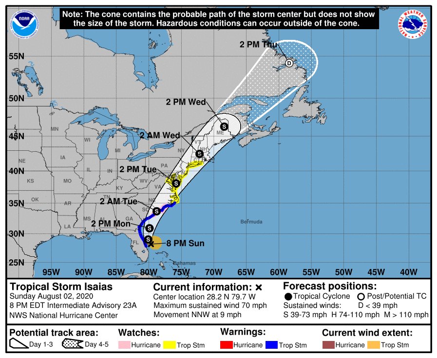
Models and ensembles of the storm’s path have remained relatively consistent, with Isaias traveling up the Eastern coast of the United States making landfall somewhere in North Carolina. The cone of uncertainty for the model forecast track stretches over a large portion of North Carolina, so the specific location of landfall is still unknown. Currently Wilmington is planning for immediate impact. Main areas of concern for the state are cities towards the eastern side of I-95. The Eastern parts of the Carolinas are expected to see between 2 to 4 inches of rain with gusty winds.
Update: Isaias was downgraded to a tropical as of 08/01 at 9:00 PM EST. Please continue to check forecast guidance from local authorities for the latest information.