
A trip along the Oregon Coast is fun and beautiful. Pacific Northwest travel views, evergreens, and plenty of fun in between.
Read MoreFire Country
Fire is a part of life in the Western US. Climate change, increasing extreme weather, and population growth in fire prone areas all combine to make fire a continuing threat to quality of life in the Western United States.
Read MoreUS Wildfire Information Page is live
Wildfires and smoke are a reality for much of the western United States. The Brown Weather Wildfire Information page is live and updated daily as more resources become available. As summer comes to an end and fall approaches, dry, windy conditions coupled with high temperatures and low humidity set the stage for the spread of wildfires. Air quality suffers when smoke travels from fires into cities and other populated areas. If you live in fire country, it’s important to be prepared for evacuation and other impacts from fires in your area. This page has a growing list of resources that help you track and prepare for fires. Visit our services page to learn more about extreme weather preparedness and risk consultation services from Brown Weather.
Read MoreBrown weather shirts and hoodies

Turbo Tropics: Twin Storms in the Gulf as Hurricane Season Continues
Turbo Tropics: Twin storms threaten the Gulf Coast as hurricane season continues
Read MoreTropical Storm Isaias forecast to impact the east coast
By Katie Melvin
Sunday Afternoon Update, 08.02.2020
Multiple Southeastern states have begun preparing for the impact of Tropical Storm Isaias with governors in North Carolina, Florida, and Virginia declaring a State of Emergency as 72 million are in the potential path of the storm. Nearly the entire East Coast of the US is bracing for impacts. The system is currently over the northwest Bahamas and will remain for the rest of tonight bringing storm surge and hurricane force winds, as well as heavy rains and flash flooding to low lying areas.

Tropical Storm Isaias heads toward the Florida coast. Image from Visible Satellite GOES East, 08.02.2020
The structure of the tropical storm from visible satellite images shows a weakening trend. Typical indicators of a well structured hurricane, such as a prominent eye and thunderstorms rising near the center, are not currently present. Infrared satellites are providing further confirmation that the storm is slightly weakening. As Isaias moves through the Bahamas and closer to Florida, there is a chance of restrengthening and it is expected to remain a hurricane as it nears the United States.
Parts of Florida’s eastern coast have issued hurricane and tropical storm warnings as Tropical Storm Isaias is anticipated to arrive late tonight and into Sunday morning. Winds are expected to be around 75 to 80 mph as the storm moves NW at 16 mph. The largest threat for Florida is flash flooding in low lying areas with parts of the state forecasting between 3 to 5 inches of rain. Isaias is not expected to make landfall in Florida, but some models show the possibility, which would cause the storm to weaken before reaching the Carolinas and maintain tropical storm strength.
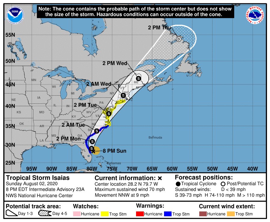
Models and ensembles of the storm’s path have remained relatively consistent, with Isaias traveling up the Eastern coast of the United States making landfall somewhere in North Carolina. The cone of uncertainty for the model forecast track stretches over a large portion of North Carolina, so the specific location of landfall is still unknown. Currently Wilmington is planning for immediate impact. Main areas of concern for the state are cities towards the eastern side of I-95. The Eastern parts of the Carolinas are expected to see between 2 to 4 inches of rain with gusty winds.
Update: Isaias was downgraded to a tropical as of 08/01 at 9:00 PM EST. Please continue to check forecast guidance from local authorities for the latest information.
5 Ways to Check the Weather
Depending on the day and how much time I have, I’ve been known to check the weather in a variety of ways. Weather is all around us all the time, but some days it is definitely more important to check in. Maybe I’m going surfing and I really want to know if the wind will stay calm through the afternoon the next day or if it’s only going to be low wind speeds in the morning, in that case, I set my alarm and leave before the sun comes up so I can catch the best waves. If I am going kayaking on a river that is already at a pretty high flow, I really would like to know if there is going to be torrential rain falling while I’m on the river that could push an exciting trip into potentially dangerous territory. I’ve come up with a variety of ways to check the weather, depending on what weather I’m interested in and what resources I have access to.
National Weather Service
If you’re interested in a big picture look at what’s happening with weather across the entire US, you can’t go wrong with a simple weather.gov visit. On the home page, you’ll see a map of all the counties in the US colored in with the different expected conditions or weather events for that day. It’s a great way to keep in touch with what watches and warnings are active in your area. There is a legend on the bottom that shows what each color means, but there are a lot of different colors, so if you’re really interested you can simply click that area on the map and it will take you to a more detailed regional report.
Private sites
Some of my personal favorites are Weather Underground, Accuweather, and the page for the College of Dupage meteorology program. The College of DuPage site is quite powerful when you figure out how to use it to its full potential. You can also check weather.com for a more news-driven look at the weather. If you’re into expert level models and forecast data, Pivotal Weather is a great site. There are a lot more beyond what I listed, keep in mind that it’s useful to be able to look at information from a variety of sources to get the best idea about what the weather could be for a given day.
Weather Apps
I have a few weather apps on my iPhone and I think this is a great way to keep weather data at your fingertips. One of my favorites was the original Weather Underground Storm, the current version is called Storm Radar, which is pretty good but the original was better. I also think the native weather app for iPhone is a good look at the current weather. Most recently, I learned about a company called Saildrone that has an iOS app that is fed, in part, by data collected with autonomous sailboats that are able to deploy in difficult conditions in the open ocean. Without Saildrone, forecast models were limited to buoy locations that can’t be moved around to collect data for different storm tracks. Look for a post about the best weather apps in the near future. Another great weather app and weather data service is ClimaCell, they offer high resolution weather forecasts and real-time updates to keep you ready for what the weather will bring.
Watch The News
Millions of people still watch TV news in the morning or evening and really count on their local meteorologist for the highs and lows, potential extreme weather, and what to expect in the long term. Al Roker and Jim Cantore are pretty much household names because of the amount of people who have tuned in to their forecasts for the last decade. When hurricanes and other extreme weather events make their way through densely populated areas in the US, you can count on regional and national news to be all over the reporting, extreme weather makes for great content and amazing stories.
Look at the sky!
Simply looking up at the clouds when you’re outside or taking note of the fog that’s been hanging around all day can start to help you build an understanding of how weather works in your area. If your app has said that it will rain every day for a week, but it hasn’t rained once, there is a mismatch between expected conditions and what is actually happening on the ground. This is important! Take a look at the sky once in a while and see what you notice, wispy high level clouds against a clear blue sky? That’s probably high pressure. A thin and uniform film across high altitudes? That could be the first moisture from an approaching cold front, high in the atmosphere. It might rain in the next few days. Has it been clear and sunny for a few days after a recent system blew through? There might be another one on the way soon. Looking at the sky and comparing it to predicted conditions from apps, websites, and news meteorology is your best bet at understanding and accurately predicting weather for your area.
The most important thing you can do is learn about what kinds of weather patterns you experience frequently in your area, then start gathering information from a variety of sources to understand what is the most reliable. A variety of sources and a proactive approach to keeping track of the weather is the best way to keep yourself from getting caught in the rain.
European Model Access is here!
Get access to the European model data!
Read MoreSnow Storm, Puget Sound
There is currently a blanket of 6 inches of snow in my back yard. 4 new inches have fallen in the past 6 hours, beginning at 1:00 pm today in Olympia, WA in the South Puget Sound. Consistently below freezing temperatures have prepped the ground and roadways for accumulations rarely seen throughout this region.
Some forecasts predict that areas around Seattle, Tacoma and the South Sound will see 16 inches of snow by Wednesday morning. This will present a challenge to a region where 30% of the economic activity is related to freight and shipping.

Source: NWS
The entire state of Oregon and all but two counties in the state of Washington are under some form of winter storm weather statement. All told, most of the populous Western United States will be experiencing some form of winter weather over the next week.

Source: NWS
The real threat is in the 10-day forecast as below freezing temperatures and continuing snowfall challenge local management agencies. Past Tuesday, Feb. 12, models are pointing to more snowfall and cold temperatures in the Pacific Northwest.